


Les Cluses-Le Perthus

CANON2
User
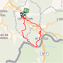

Length
14 km

Max alt
385 m

Uphill gradient
470 m
Km-Effort
20 km

Min alt
130 m

Downhill gradient
399 m
Boucle
No
Creation date :
2019-05-15 13:09:55.249
Updated on :
2019-05-15 13:09:55.45
3h30
Difficulty : Medium

FREE GPS app for hiking
 SityTrail
IGN / Geographical institutes
SityTrail Plus
The world is yours!
About
Trail Walking of 14 km to be discovered at Occitania, Pyrénées-Orientales, Les Cluses. This trail is proposed by CANON2.
Description
UN PEU CONFUS AU NIVEAU DES RUINES ROMAINES
Positioning
Country:
France
Region :
Occitania
Department/Province :
Pyrénées-Orientales
Municipality :
Les Cluses
Location:
Unknown
Start:(Dec)
Start:(UTM)
486684 ; 4703785 (31T) N.
Comments